This year's challenge is 52 Ancestors in 52 Weeks and is run by Amy Johnson Crow.
Information on the Topic
Week 38's theme is "On the Map." Location is key for our research. What is a discovery you've made using a map? Any ancestors found a town? What about a family who lived in a town with a strange or funny name?
I used maps to help in several of my family searches and research. Once I find major proven information out (Birth, Deaths, Marriages) I try and go into Google Earth (what a saver!) and plot where people have been by using documents, books or even newspaper clippings.
For instance, when I found a book on the area my paternal grandmother Jean lived in her life in Poland, I plotted where her, her mother and her parents were known to be in. Then when I read Heart of Europe: The Past in Poland's Present, although very dry, it gave a great insight to what was happening around the time my grandmother and great grandmother left Poland and where the smaller battles were going on.
Because of this, I could map out where the battles and my grandmother and great grandmother were around the time they lived and started to head towards the coast where the ship manifest is dated from. Add that to the newspaper clipping of when the Danzig port opened and closed, and you get a good sense as to what they went threw by using a map.


I have been trying to figure out how relatives in Minnesota and others parts of the midwest are connected. One way was by mapping the people we know emigrated to the US and those ancestors who come from the area like above. In doing this, I found one of the witnesses for some paperwork on Sylvian and Camille had the same last name as one of my ancestors, Joanna Vandesdrissche (my 4 times great grandparent). I think either her brother/cousin signed a form. Also, as you can see they were from a nearby town from Sylvian and Camille. Maybe they had other siblings or cousins which married which is how we're connected.
Another way maps help or can be used, is to see how history plays a part in what your ancestor did or maybe a reason why they moved or even died.
For instance, take the map above of Belgium and my relatives. Notice the yellow line? This line is the border between France and Belgium. Wytschaete is especially of interest as we have many people born there to at least 3 generations (and as far as I've gone back which is the early 1700s).
Now, think about history. I'm not thinking the 'tiny' battles. I'm thinking World War 1. Remember, World War 1 was for 1914-1918.
Now I'm going to put up a map of World War 1's Western Front.
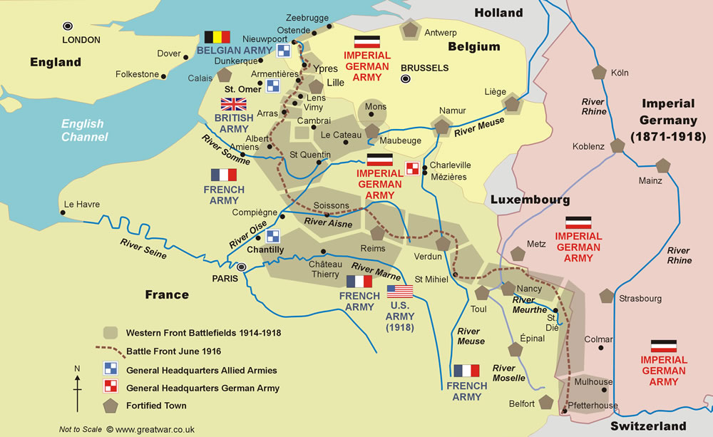
Can you see the brown dotted line where the active line would have been? Credit
Thankfully, my direct ancestors had left by this point (they left in the mid 1890's), but they still had siblings and family all around this area. Remember too, the connections with the mid-western Gauquie's were here around this time (the blue dots on the map above). Now think about what would have been happening and all the confusion and death around.
Another question that once was posed to me was about the French Revolution. The location was in France and wasn't directly by the family, but the area they lived in backed onto France. According to the information below, the one town (Wijtschate and most people know Dig Hill 80) where we had at least 3 generations of my family living, was around this time (look at the Belgium map above).

A Drawback
As you can see above, I use Google Earth as a tool to do many different things and help in different ways. However, I found sometimes the developers do something and Poof! All my places I've had mapped out are gone. It's completely gone for all of it. It gets to really be heartbreaking because then you have to go back and put it all in again. There used to be a way to save all of the places at once but that option is now gone. I'm still trying to workout how to combat this without having to redo everything.
As you can see, maps can be used in many different ways depending on what you want to accomplish. If you haven't used this way of researching a difficult to find ancestor, you might want to give this a shot.
Warning though. It sometimes doesn't work at all. For instance, my maternal 2x great grandparents were from Belgium and Denmark. They met in the US and lived in the Hudson Valley in New York. However, it took me to find a newspaper article and their naturalization papers to find where they actually got married - St Paul, Minnesota.
I don't actually have any reason to know exactly why, but I'm thinking maybe my 2x great grandfather went to visit the midwest cousins and on the way back met my 2x great grandmother. It's the only thing I can think of as to why he would be over there. Although it could be he might have been looking into the land scheme for that area as he finally settled into New York as a dairy farmer.
No comments:
Post a Comment